Scan to see this page on your mobile phone
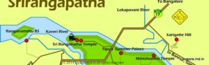
Kabini is not a place , rather a river's name. So for the sake of simplicity let's assume that Kabini as a destination mentioned here is the places around Kabini's backwaters on the fringes of Nagarhole forests, where the Kabini dam is located.
Even that's quite a large area spanning many hundred square kilometers.
So the route described here is all about how to drive from Bangalore to Kabini, to be specific one of those tourism destinations in Kabini.
Let's divide the whole affair of driving fro Bangalore to Kabini into 4 phases, and see how things are like driving directions, road conditions, distances , driving times and so on .
Phase 1: Get out of Bangalore city
Phase 2: Drive to Mysore
Phase 3: Cross Mysore City
Phase 4 : Drive to HD Kote
Phase 5 : Drive to the destination in Kabini
Get out of Bangalore city: There are any number of theories and ideas to navigate the Bangalore traffic, and get out of the city. Some may suggest you to drive right through the city, while other may recommend you to use the Ring Road or NICE Express way. You are the best judge to pick one based on where are in Bangalore. Keep in mind the NICE road crosses the Bangalore-Mysore highway (SH17), an ideal point to get into the SH17 towards Mysore. That marks the end of your first phase of journey to Kabini from Bangalore.
Phase 1 could take anything from 30 to 90 minutes based on your location in Bangalore and time selected to start.
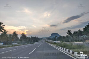
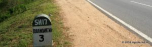
Drive to Mysore: Once on SH17, it's pretty straight forward till you hit the outskirts of Mysore City. See Bangalore to Mysore by Road for detailed driving directions. Keep in mind, gone are the days when the highway between Bangalore and Mysore was a pleasure drive. You'll find considerable traffic especially during the weekends , though relatively fast moving.
Account for about 3 hours from the outskirts of Bangalore (SH17-NICE junction) to the outskirts of Mysore City (Colombia Asia Hospital junction at Mysore). That includes a 30 minutes of break at one of those many drive-in restaurants between Bangalore and Mysore.
The road condition is pretty good with 4 lane all the way, though there are frequent speed-breakers.
Cross Mysore City: At Colombia Asia Hospital junction the SH17 crosses the Outer Ring Road. There are two ways of passing Mysore city. The first is about driving right through the Mysore City and the second is about going around it using the Outer Ring Road . Your target is to get to the HD Kote Road ( also called Mananthavady road) that connects Mysore with Kabini.
If you opt to drive right through the city, (unlike Bangalore, Mysore is a small city , not very difficult to drive through the city center), head to the Mysore Railway Station first. That is from the Colombia Asia junction, continue straight on the SH17 till you reach Mysore City center. The railway station is about 6km from this junction.
There are two roads leading out of the railway station, the JLB Road and Irvin Road. Take the JLB Road.About 3km from the railway station on the JLB road you'll hit the Srinivasa Circle. Turn right to the Mananthavady Road.
About 5km from Srinivasa Circle, you'll cross the Outer Ring Road again. If all well you will cross Mysore city (between the two ring road junctions ) in 30 minutes time.This is about 14km.
On the other hand, if you prefer to use the Outer Ring Road around the city, turn right at the Colombia Asia hospital signal. Cross the KRS Road, Cross the Hunsur Road and continue straight on the Ring Road till you hit the Mananthavadi Road junction. That's roughly 21km between the two junctions on the Ring Road.
This marks the exit of Mysore City.
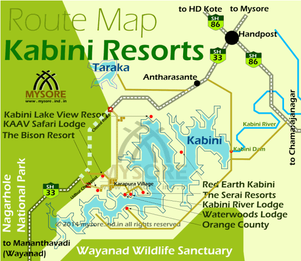
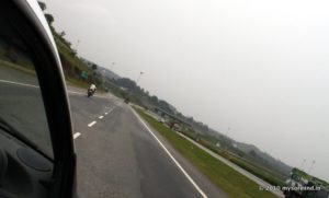
Drive to HD Kote : Once on the Mananthavady Road (SH33) to HD Kote you will drive through laid back countrysides for about 40km, till you hit the Hand Post Junction. You should reach here under an hours drive from Mysore. It's a 2 lane curvy route. The road condition is pretty good, and the traffic is much less than any of the stretches you've driven so far from Bangalore. There are no great restaurants or any such facilities after you've left Mysore.
You'll find a fuel station at the Hand Post Junction. This hyperactive junction stands in stark contrast with the easy road you've been on from Mysore.
There is a road towards left and another to right.Right goes to Hunsur and Coorg. The left one goes to Sargur and Gundlupet. Your route to Kabini is the straight one from the junction. Wriggle through this junction. In no time sanity prevails and you are on a lonely road again!
About 3km after you've crossed the Hand Post junction, you'll hit another junction - the Kabini diversion. From here onward you've to select to route based on your final destination in Kabini.
Drive to the destination in Kabini: Is your destination Kabini Dam? Or the Orange County resort in Kabini? Keep driving straight at this junction. You'll be leaving the SH33 to a relatively narrower road.
Kabini Dam is about 10km from this junction. Orange County is another 20km from the dam.
If your destination is the Jungle Lodges (JLR), Serai Kabini , Kaav, Waterwoods, Bison Resort , do not drive towards the Kabini Dam. Keep driving on the main highway from the Kabini dam diversion point. In fact the main road (SH33) make a right bend at this junction. You'll see a few sign posts giving directions , including those of the resorts mentioned that are on the banks of the Kabini backwaters.
In about 12km from this junction you'll hit a closed gate across the highway. This marks the entry to the Nagarhole National Park (Rajiv Ghandi National Park). The place is called Dommana Katte and there is a forest checkpost next to the gate.
Traffic through the national park is prohibited, so the closed gate.
Just before the gate, you'll see a left diversion. There are ample sign posts by the plethora of the safari lodges , all asking you to make the left turn!
This diversion road will take you to a village called Karapura. The road has been bad for quite long, making this drive through this diversion a nightmare. Not anymore. The road condition is superb all the way to Karapura, and beyond all the way to Kerala boarder.
From Dommana Katte diversion to Karapulara village square distance is about 9km. At Karapura you've to take a left diversion to Jungle Lodges (JLR), Serai Kabini , Waterwoods Safari Lodges. This is a 3km diversion through a bumpy village road till the edges of the Kabini Backwaters where these 3 safari lodges are located ( almost side by side, though about a kilometer apart)
Kaav safari lodge is a right diversion a bit before Karapura village square, and Bison camp diversion is a little ahead of the Karapura village. Both are a short bumpy diversions from the main road you've been on so far.
By the way, if you did not make any diversions, a couple of kilometers ahead you'll enter the Nagarhole forest through the Udbur gate. The road though the forest now goes all the way to Karnataka-Kerala boarder at Bavali. That's where you'll enter Wayanad of Karala.